Saturday 30th September 2023 – Urban (National) event in Brandon, Durham.
Results now published
Covid-19: This event has been organised to comply with current guidance from the Government and BO with respect to the ongoing COVID-19 problems. Please follow any notices and directions from club officals, but more importantly try to keep in mind sensible social distancing, both in the parking area and also whilst competing.
Additional information is required of competitors to allow NHS Test and Trace if a problems arises from the event. Pre-entry requires entrants to acknowledge that they must not attend if they or a member of their household has COVID-19 symptoms, or if they have been asked to isolate by NHS Test and Trace, and that they will abide by the Participant Code of Conduct at all times.
Day 1: Urban national event in Brandon, Durham
Venue: Day 1 of October Odyssey 2023 will be held around Brandon. This is an urban area close to Durham City. The area includes parkland around Meadowfield Leisure Centre and complex housing areas around Brandon. This is a new map, with this area previously only being used for NN Club Nights. Event centre is at Meadowfield Leisure Centre, DH7 8RG.
Travel by car: approach along the A690 (Durham to Crook), turn into access road for Meadowfield Leisure Centre, turn right into County Council car park.
Travel by train: There is a limited service to Durham Station on the day of the event due to industrial action. Durham station is 20 minute by bus or 4km on foot from event enquiries.
Travel by bus: X46 from Durham to Crook (operated by Arriva). Note that the Angel 21 Go North East service from Newcastle is likely to be effected by industrial action.
Cycling: the venue can be accessed via the Lanchester to Willington cycle path. Bike racks are available at the leisure centre.
Parking and Assembly: Durham Council Offices car park (no charge), John Street North, Meadowfield, Durham DH7 8TZ adjacent to Meadowfield Leisure Centre. Google Maps What3Words: ///hike.blaze.square NZ 248 399
In the event that this parking area becomes full, additional parking can be found on St John’s Road. This is the next left turn after the Meadowfield Leisure Centre when heading south west on the A690 (away from Durham). This is free on street parking – please park courteously for local residents/businesses. Google Maps What3Words: ///margin.trains.bench NZ 249 398
Entries: Online entry is now closed but you can look at the start list at ![]()
Novice courses (Light Green/Yellow) are available as entry on the day.
Late Entries: there may be some extra maps. Please contact the organiser to check availability info@northern-navigators.org.uk
Entry on the Day: limited to Novice courses (Light Green/Yellow) and aimed at newcomers. £5 per map +£1 dibber hire.
Enquiries/Download: Open from 10:30 located in a white van at the edge of the parking area. Hired dibber collection, Yellow course map collection and novice entry on the day from here.
Fees: Senior BO members – £10, Senior non BO members – £12, Juniors/Students/Adult Novice Course – £5
Start: 11am-12:30pm. Punching start with a -4 minute call up. Choice of Early/Middle/Late start blocks.
Note that there are two starts, routes to both starts will be taped from Enquiries:
Near start – Yellow/Light Green courses – ~150m from Enquiries (collect Yellow course map from Enquiries before heading to start)
Far start – all other courses – ~650m (20m climb) from Enquiries.
There is no clothing dump provision at either start location.
Finish: Common finish for all courses, ~250m from Download/Enquiries. Follow taped route – all competitors must report to download even if you retire.
EPS: This event will use the SportIdent electronic system. Control stations will be enabled for touch free punching (SIAC) but competitors will need to punch the start and finish control. All control sites will have a backup system in the event of control failure. This involves a tag with a unique 3 letter word instead of the traditional punch. Remember the word and report it to the download team to prove you have visited the control. Note that the Black Course has 31 controls and therefore SI-Card 8 do not have sufficient storage for this course and SI-Card 5 will not record a split time for the last control. Competitors with these SI-Cards will be contacted regarding a free dibber upgrade – please visit Download/Enquiries to collect your SI.
Hired Dibbers: Dibber hire is available for £1 – choose this option with Racesignup. You’ll need to pick up your hired dibber from Enquiries before you go to the Start. Lost/damaged dibbers will be charged at £30.
Map & Area: Brandon – mapped by Allen Banister (2022/23). This is the first event for which this map has been used. The original 26 houses in Brandon Village are included on the map, but most of the area is built on the site of the demolished old colliery and it’s terraced houses. See the following Northern Echo article for further details of its History. The current housing includes lots of footpaths, open space green space, small wooded areas and a section of the national cycle route 70.
There has been some recent housing demolition in preparation for new housing in the middle of the map that is fenced off and marked as out of bounds. There are also several football pitches within Meadowfield park- these are marked as out of bounds and will likely be in use during the event!
The map is 1:5000 with 5m contours (1:4000 on Yellow and Lt Green).
Map Symbols: Please remember that the following denote out of bounds/uncrossable features for an Urban event:

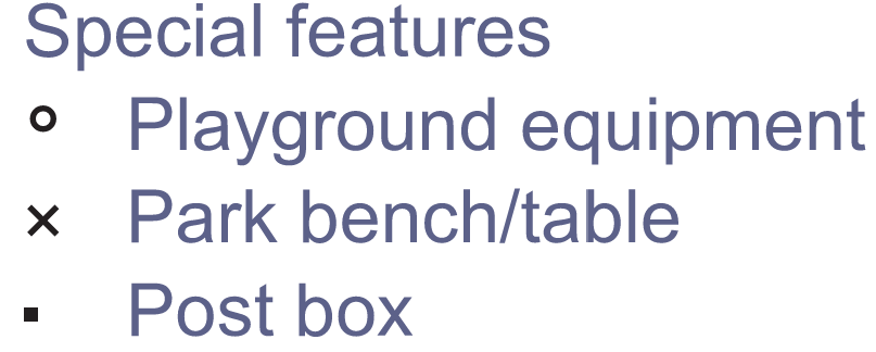
The map follows ISSprOM 2019-2. The following Special Symbols are used:
Safety Information: First Aid will be available at enquiries/download. Courses close 14:30. Short leg cover may be worn.
All Under 11s must be shadowed by a responsible adult, other juniors may be shadowed if desired. Both the Yellow and Light Green courses contain uncontrolled crossings of minor housing estate roads with good visibility. M/W16s will only be permitted to “run up” if they are 16 or over on the day of the race.
Note that orienteering is an adventure sport. A comprehensive risk assessment for the event has been prepared and identified risks have been mitigated, however please be aware that participants take part at their own risk and are responsible for their own safety during the event.
Control descriptions: descriptions will be on the map and loose descriptions will be available in the start box
Facilities: Toilets will be available in the leisure centre, 2 minutes from the parking. Please treat the facilities respectfully e.g. remove shoes if muddy.
Basic First Aid facilities will be available at enquiries.
Sorry, there will be no water at the finish, please bring your own supply.
Dogs: Dogs will be allowed, but please clean up after your dog.
Thanks: Many thanks to Meadowfield Leisure Centre for use of their toilets.
Officials:
- Organiser – Matthew Foskett
- Planner – Kath Marshall-Ivens
- Controller – Rob Bailey (CLOK)
Courses:
| Course | Classes | Length | Climb | Map Size | Scale | Start |
| Black | Men’s Open (M18-M35) | 9.3km | 320m | A3 | 1:5000 | Far |
| Brown | Vet Men (M40+) / Women’s Open (W18-W35) | 7.9km | 205m | A3 | 1:5000 | Far |
| Blue | Supervet Men (M55+) / Vet Women (W40+) | 5.2km | 175m | A3 | 1:5000 | Far |
| Green | Ultravet Men (M65+) / Supervet Women (W55+) | 4.1km | 135m | A3 | 1:5000 | Far |
| Short Green | Hypervet Men (M75+) / Ultravet (W65+), Hypervet Women (W75+) | 3.1km | 125m | A4 | 1:5000 | Far |
| Light Green | Junior Men (M16-) / Junior Women (W16-) (also Adult Novice) | 2.8km | 115m | A4 | 1:4000 | Near |
| Yellow | Young Junior Men (M12-) / Young Junior Women (M12-) (also Adult Novice) | 2.0km | 65m | A4 | 1:4000 | Near |
All course lengths are straight line distance. Optimal route is approximately 15-20% longer for all courses.
Note: All Under 11s must be shadowed by a responsible adult, other juniors may be shadowed if desired. Both the Yellow and Light Green courses contain uncontrolled crossings of minor housing estate roads with good visibility. M/W16s will only be permitted to “run up” if they are 16 or over on the day of the race.
For beginner orienteers there is the option to enter on the day for the Light Green and Yellow Courses – we’ll happily explain how orienteering works on the day! Find an explanation of colour coded courses here.
Results
Routegadget
Splits Analysis (Available in Routegadget)
British Orienteering (Ranking points should appear on Sunday).
Photos taken by Dougie.
Organiser’s Comments
Thanks to everyone who came to this event – the new area and all the courses seemed to be really well received which was great. Thanks to all the volunteers and also to the Council/Leisure Centre for use of the area and toilets – we look forward to running another event here soon!