
October Odyssey: a weekend of orienteering (Level B) in the North East of England.
Day 1: Chopwell Woods (incorporating the selection race for the England Junior Team for Interland 2027). Chopwell is a mixed woodland on the fringes of Gateshead, 18 miles from Durham, 12 miles from Newcastle.
Day 2: Edges Green (incorporating the North East Championships). Details available here. Edges Green is 2 miles north of Hadrian’s Wall, about 3 miles from the infamous Sycamore Gap and 5 miles from Haltwhistle. The YHA (3 miles away) offer accommodation at The Sill for anyone wishing to make a weekend of it.
Final Details for Day 1:
Venue: Chopwell Woods. SatNav Postcode NE39 1LT
Travel by car: Chopwell Woods is approached from all directons along A694 and accessed using B6315, signposted from the village of High Spen.
Travel by bus: bus number 47 (Go Ahead Northeast) operates from Newcastle Central Station to High Spen from where it is a 15 minute walk to the assembly.
Parking: cars will use the existing car parking facilities for Chopwell W3W///resonates.imitate.every The wood is used by members of the public – please follow marshall’s directions. There is a parkrun operating before our event which also uses these facilities. The access road to Chopwell is single track with passing places so arriving after 10:00 will avoid parkrun vehicles exiting. Alternatively, arrive before 9:30.
Assembly: EOD, Enquiries, Dibber Hire, White and Yellow course map collection, First Aid, Toilets, Cake Stall, Download will be located in the Chopwell classoom a 7-minute walk from parking, on the way to the start. Please note there is no parking for cars at the classroom and be mindful of local residents when in the vicinity of the classroom.
Entries: Online entries are now closed. There is a limited supply of spare maps – please contact the organiser to reserve.
Entry on the Day: Light Green, Orange, Yellow and White available subject to availability
Junior Interland Selection Race: accessible to any M/W14, M/W16, M/W18 wishing to be selected for England Interland 2027. Juniors should enter the recommended course and arrive at the start for their chosen start block where they will be set off at 3 minute intervals.
Enquiries/Download: Open from 10:30, located in the classroom.
Cake Stall: please support our juniors by visiting the cake stall located in the classroom. They are raising funds for the NEJS offering baked goods, beverages and orienteering themed products. Cash preferred but phone payments accepted.
Fees: Senior BO members – £12, Senior non BO members – £14 (see below), Juniors/Students – £5.
Enter both days and save £4 (seniors) £2 (juniors)
BO Non-Members: Important notice – non-members are not insured under British Orienteering’s public liability policy. By entering this event, you acknowledge that you are participating at your own risk.
Start: 11:00-13:00. Please arrive at the start during your chosen start window. Punching start with a -4 minute call up. White and Yellow course participants should collect their map from Enquiries.
Start Location: Follow tapes south west from the parking along the forest road. Arriving outside Enquiries/toilets (in the classroom), you will see a sign to the start – approximately 10 mins from parking. Clothing can be left at Enquiries at the owner’s risk.
Finish: Common finish for all courses, ~250m from Download/Enquiries. Follow taped route – all competitors must report to download even if you retire. Courses close at 15:00
EPS: This event will use the SportIdent electronic system. Control stations will be enabled for touch free punching (SIAC) but competitors will need to punch the start and finish control. All control sites will have a backup system in the event of control failure. This involves a tag with a unique 3 letter word instead of the traditional punch. Remember the word and report it to the download team to prove you have visited the control.
Hired Dibbers: Dibber hire is available for £1 – choose this option with Racesignup. You’ll need to pick up your hired dibber from Enquiries before you go to the Start. Lost/damaged dibbers will be charged at £30.
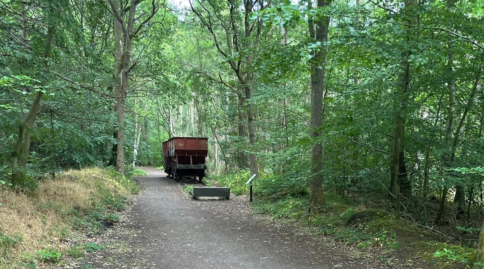
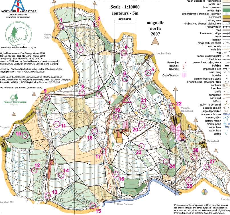
Map & Area: Chopwell Wood is 900 acres of wonderful mixed woodland with a large network of tracks and paths, it has a history of both mining and wood production, there is a track in the wood that was an old railway line, about 30m of which has been left in place (see photo above). Chopwell is public access and part of Forestry England’s “Feel Good in the Forest” project, which is aimed at improving physical and mental health. There is one MTB track that is clearly marked on the map, however MTBs do use many of the paths and tracks in the area. The map has been recently updated by Allen Banister. There are no previous events on Routegadget, so a copy of an old POC is shown below.
The map is 1:10,000 with 5m contours.
Safety Information: First Aid will be available at enquiries/download.
Ticks are present in the forest and full leg cover is required. Ticks can carry Lyme Disease, please check carefully for attached ticks at the end of your run and remove; for guidance see the NHS website NHS – Tick Removal
Ant hills, sometimes a meter in diameter/height, have been seen in some parts of the forest; please avoid!
Courses close 15:00.
Note that orienteering is an adventure sport. A comprehensive risk assessment for the event has been prepared and identified risks have been mitigated, however please be aware that participants take part at their own risk and are responsible for their own safety during the event.
Control descriptions: descriptions will be on the map and loose descriptions will be available in the start box
Facilities: Toilets will be available in the Chopwell classroom, 7 minutes from the parking. Please treat the facilities respectfully e.g. remove shoes if muddy.
Basic First Aid facilities will be available at Enquiries.
Sorry, there will be no water at the finish, please bring your own supply, but beverages will be available to purchase in the classroom in aid of NEJS.
Dogs: Dogs will be allowed, but please clean up after your dog.
Thanks: Many thanks to Forestry England for granting access to the forest and to Lucy Brenkley, the forest ranger for her help and access to the classroom.
Officials:
- Organiser – Debby Warren (NN) email: northernnavigators@gmail.com
- Planner – Maya Hampshire-Wright (NN)
- Controller – Frank Shillitoe (NATO)
Provisional Courses:
| Course | Classes | Length | Climb | Scale | Map size |
| Brown | M18, M20, M21, M35, M40, M45 W21, W35 | 9.2 km | 230m | 1:10,000 | A4 |
| Blue | M16, M50, M55, M60 W18, W20, W40, W45 | 6.1 km | 140m | 1:10,000 | A4 |
| Green | M65, M70 W16, W50, W55, W60 | 4.2 km | 125m | 1:10,000 | A4 |
| Short Green | M75 W65, W70 | 3.2 km | 65m | 1:7,500 | A4 |
| Very Short Green | M80, M85, M90 W75, W80, W85, W90 | 2.2 km | 50m | 1:7,500 | A4 |
| Light Green | M14 W14 | 3.3 km | 125m | 1:7,500 | A4 |
| Orange | M12, M14B W12, W14B | 2.5 km | 95m | 1:7,500 | A4 |
| Yellow | M10, M12B W10, W12B | 2.1 km | 70m | 1:7,500 | A4 |
| White | M10B W10B | 1.3 km | 40m | 1:7,500 | A4 |
Ticks: if you haven’t already, please check for ticks. They were in abundance today!
Routegadget now available at 2026-10-03 Chopwell
Splits Analysis courtesy of Routegadget
Organiser’s Comments
I hope you enjoyed Chopwell Woods in the glorious sunshine today? The courses seemed to be well received despite the challenging nature of the terrain and it was nice to get back into Chopwell after a long absence. We were very pleased to welcome so many orienteers from far flung corners of the country; there was a great vibe in the woodland classroom with people mingling outside making the most of the autumn sun and partaking of the cakes kindly supplied by our volunteers. Thank you for coming!