Welcome to the 5th Edition of NNews – a quarterly newsletter from Northern Navigators. This edition has a CompassSport Trophy focus after we successfully qualified for the final – make sure to add that and other upcoming events to your diary!
The newsletter contains details of upcoming events and contributions from our members. Thank you to everyone who has contributed to this edition.
Please let us know ([email protected]) if you have any comments or wish to contribute to any future editions.
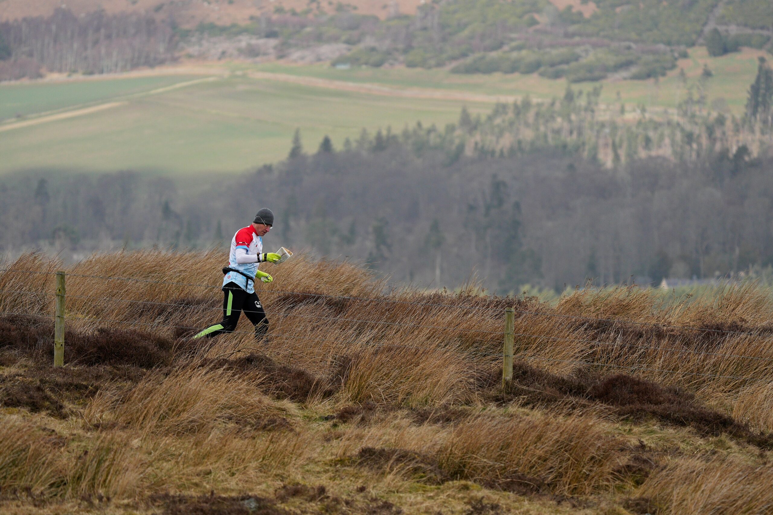
(Thanks to Paul Bartlett of NATO for taking the photo included above, it is of Dougie Nisbet at the CompassSport Trophy Heat at Beanley)
Upcoming Events
Note: Some details are provisional, always look at the website of the organising club for final details.
Sunday 23rd April – Rising Sun Local; Rising Sun Country Park (NATO, local)
Wednesday 3rd May – Street-O No. 1; Newton Hall, Durham (NN, local)
Saturday 6th May – Spring LOP No. 4; Weetslade Country Park, Wideopen (NATO, local)
Saturday 6th May – NYMBO #3 – Paradise Farm; Boltby, Thirsk (NYMBO, Mountain Bike Orienteering)
Sunday 14th May – Urban; Fellgate (NN, regional)
Saturday 20th May – Urban (UKUL); Killingworth (NATO, regional)
Sunday 21st May – Classic Middle Distance; Lords Stone, Stokesley (CLOK, regional)
Tuesday 30th May – Summer Series No. 1; Rockwell Park, Darlington (CLOK, local)
Saturday 3rd June – Spring LOP No. 5; Wylam (NATO, local)
Tuesday 13th June – Summer Series No. 2; Bassleton Woods, Thornaby (CLOK, local)
Saturday 17th June– NN Local Summer Series (Come and Try It); Herrington Country Park (NN, local)
Sunday 18th June – Cumbrian Galoppen; Binsey, near Bothel (BL, regional)
Wednesday 21st June – Street-O No. 2; The Sands, Durham (NN, local)
Tuesday 27th June – Summer Series No. 3; Coatham Dunes, Redcar (CLOK, local)
Saturday 8th July – Summer Series No. 4; South Park, Darlington (CLOK, local)
Sunday 9th July – Town Centre Urban; Darlington (CLOK, regional)
Saturday 15th July – NN Local Summer Series (Come and Try It); Hetton Lyons (NN, local)
Wednesday 19th July – Street-O No. 3; Riverside Park, Chester-le-Street (NN, local)
Sunday 30th July to Friday 4th August – Scottish 6 Days; Moray (national)
Thursday 17th August – Street-O No. 4; Belmont, Durham (NN, local)
Saturday 30th September – October Odyssey Day 1; TBC (NN, national)
Sunday 1st October – October Odyssey Day 2; TBC (NN, national)
Sunday 12th Nov – CompassSport Trophy Final; New Beechenhurst, Forest of Dean (BOK, Major)
Tuesday 26th Dec – Boxing Day Charity Score; TBC (NN, local)
We also have a weekly club night on Wednesdays at 6.30pm in the vicinity of Durham City. Contact [email protected] for further details.
October Odyssey Weekend – 30th September and 1st October: Dates for your diary
Debby Warren
On the 30th September and 1st October we are organising 2 national events and will need a lot of volunteer helpers please.
Jobs will include car park marshals, first aiders, registration and download, enquiries and control collection. Organisers for the two days are Julian Warren and Matthew Foskett. I’m sure they would both appreciate your input on one or both days so please keep the dates free. Remember, helpers get a 50% discount on the entry fee. Thank you.
CompassSport Trophy Heat: Part 1, A review from Debby
Debby Warren
We’re on our way to the Final!
The Compass Sport Trophy competition is always high on the events calendar agenda; mainly because we want to beat a neighbouring rival club (who shall remain nameless) but this year we outdid ourselves by actually winning the heat! This is a very rare occurrence for us. After some brief research I have discovered that we got to the final in 2011 at Longshaw in the Peak District where we came 10th out of 11 participating clubs. On this occasion, I counted about 15 hardy NN performances. Again in 2013 we appeared in the final which took place coincidentally in the Forest of Dean, achieving 10th place (but also sadly last place) and fielding 8 runners. In each case, FVO were the winners (since then they have moved into the Compass Sport Cup category as a larger club but others have replaced them – INT seem to have done consistently well in recent years).

Judging by our performance this year I can’t wait to see what we can do at the final in November. Obviously, we had a good turn out this time as the event was in our neck of the woods but we also had some outstanding performances.
It may be beneficial at this point to explain the scoring system. Firstly, we must enter people for the correct age category. This means that you can “run up” (do a harder/longer course) but not “run down” eg a W50 should do Green, however can also do a course above such as Blue but not an easier course like Short Green. All runners are given a score according to their position on their course but Cup and Trophy participants are counted separately. First place runners get 100 points and second place 99 etc. The top two scorers for each club on each course are then selected and out of these, the top 13 scores make up the final score. Those that don’t get to score in the top 13 contribute by taking up places and so points from other clubs. In the end, this can be significant when the scoring is tight.
At Beanley we had healthy numbers on most of the courses so no-one needed to run up although interestingly, several categories had no NN representation: Green Women W45+, Green Juniors M18- and Very Short Green W70+/M80+. The Men’s Open was particularly impressive; we had 4 runners – more than any other club! Out of the 23 runners we fielded, 6 achieved the maximum 100 points (Barney, Rob, Nigel, Saskia, Bob and Thomas) ,and we also had a lot of high scoring lower places showing strength in depth (Max, Andrew, Clare, Allen, Boris, Debby and Phoenix). In the end the scoring was very tight: NN – 1280, BL – 1277 and NATO – 1274. Particular mention should be made of our new members: thanks to Thomas and Phoenix – our first Junior Men for a while who incredibly ran Orange for the first time ever on their own at this event, Rob and Clare who both scored for the club and Horst who did the Blue course – his first experience of an event outside of club training. Well done to Roberta who competed for the club for the first time and a special congratulations to Bob who won the Veteran Short Green outright! Basically, well done and a huge thanks to everyone who took part!
No pressure……but see you all at the final where although we have no chance of winning, I’m sure we can improve on 10th/11.
Club Nights
Debby Warren
Our weekly club training continues to be well-attended and a popular way to concentrate on technique or fitness. The venue changes each week but usually within a 5 mile radius of Durham and is operated via a WhatsApp group. If you would like to join, get in touch with me and I’ll add you to the group. Alternatively, the details are put on the website each week (usually by Monday). During the winter we have replaced one Wednesday evening each month with a Saturday morning to take advantage of daylight hours so if you can’t make an evening we hope to see you on a Saturday!
CompassSport Trophy Final Accommodation
Dave Peel
As you hopefully know, we won the CompassSport Trophy heat at Beanley and so have qualified for the final. This will be taking place on the 12th of November, in the Forest of Dean! (Coincidentally the same place it was when we last qualified 10 years ago). We are looking into organising group accommodation for the weekend – Friday night till the Sunday. There is a local level event hosted by NGO in the Forest on the Saturday as a warm up event (though you can do as you please to be honest).
Anyway it would be useful to have a idea of how many people would want accommodation so can you please let me know the following:
1) whether you are likely to attend
2) whether you are interested in group accommodation (I know some people might wish to stay with friends, relatives or just as a family group). Price is TBC, but expected to be £60-£80 per person for the weekend.
Ideally as soon as you can there is a limited number of larger accommodation available.
Summer Street-O Series
Matthew Foskett
This summer we will be running a series of Street-O events – the first event will be Wednesday 3rd May in Newton Hall, Durham. They will then run approximately monthly on a weekday evening (usually replacing a Wednesday Club Night) through the summer months. All are welcome – please invite anyone you know who may be keen to try orienteering!
Each event is a score course (visit as many controls as you can within the time in any order). All the controls will be items of street furniture (e.g. a lamp post) – at each control you will be asked to write down something (e.g. lamp post number) to prove that you have visited.
For full details check the website for each event.
I’ll be organising the series, but it’d be great if anyone else is interested in having a go at planning the course for an event – it’s really simple – just drop me a line if you are keen. Dave Peel has kindly agreed to plan the first event.
CompassSport Trophy Heat: Part 2, A review from Thomas
Thomas Puschmann
On Sunday 12th March 2023 there was the CompassSport Trophy heat in Beanley, which I took part in along with many other orienteers.
This was the first time I had entered an orienteering competition so I was nervous to start with, but once I was there it was very fun. The box start seemed so formal when explained to me, but it turned out to just be some tape on the ground with some friendly people in woolly bobble hats who explained what to do. The start was in the middle of a snowy bog so everyone took the first few minutes to pick their way through the mud. After carefully dodging my way through the start I realised that the rest of the paths were just lakes as well so I didn’t really bother trying to keep my feet from getting wet.
Each control was a stick with a small box on top and that box had a number on it which corresponded with the number on the map. To prove that I had been there I had a dibber, which is a small cylinder with a strap on it to put on your finger. In the top of the box there was a hole which you were meant to put the dibber into. The course took me up a hill covered in knee deep heather and down a very steep slope on the other side. I had to run through some fields which had lots of controls in them because the white Yellow and orange converged there, and then I finished in a small thicket. Once I had finished, I had to dib the finish and then go back to the car park to upload my results.
There was still lots of time, so I had a cake from the cake stall and went back to do the yellow course which was easier because I knew where some of the controls were. The club did really well overall so we are going to the final in the Forest of Dean in November which I am really looking forward to.
Thank you to Debby and all the other Northern Navigators for looking after me on the day and welcoming me to the club.
Brimham Rocks
Saskia Warren
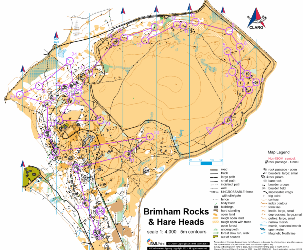
Brimham Rocks prove to be a very popular location within the UK due to the unusual rock formations. The sandstone material that makes up the rocks is thought to have been deposited by a powerful river over 300 million years ago before even the dinosaurs existed! They became exposed after the last ice age 100,000 years ago and gradually from then to the present day weaker rock material has been eroded or weathered away leaving the fantastic, dramatic features we see today. Visitors come from far and wide to experience the mystical vibe of the area, in particular rock climbers love the unique challenge it provides, and February the 12th was no different with orienteers swarming the National Trust car park eager to uncover the secrets of Brimham Rocks (and maybe also to become the YHOA middle distance champion but who can say for sure).
After taking every possible space in the car park the next task was to find the toilets which proved surprisingly difficult for the Warren family with Debbie leading us on a wild goose chase (foreshadowing?). We finally got our bearings and our first sneak peek of the area with towering rocks on both sides and some visible controls to store away in the back of our minds in case they were useful. Pre-race prep done and it was off to the start where another hurdle was encountered… Queueing. Something English people stereotypically love doing apparently but not these orienteers who were beginning to get restless. Luckily for me the Black course was not as popular as some others, either that or I had successfully intimidated my rivals but more likely the former. 4 minute wait time and I was off!
The first 5 or 6 controls were going smoothly and I was beginning to wonder what all the fuss was about, navigation didn’t seem that hard! Granted I had taken the first few slowly to get a feel for the map and because I am notorious for rushing at the start and spending half my time on number one, whoops. However, by number 15 I was starting to realise I had not even scratched the surface of Brimham yet and the massive boulder in the way of control 16 had me well and truly fooled. Not only was I tricked once by a dead end but thrice, it turns out the earlier boulders had been child’s play and this one was not so easily beaten. I finally made my way round to control 16, after an embarrassingly long time considering how short the leg was, and if I thought that was bad I had another thing coming because lying behind that fence was a maze of rocks, tunnels and bouldering mats.
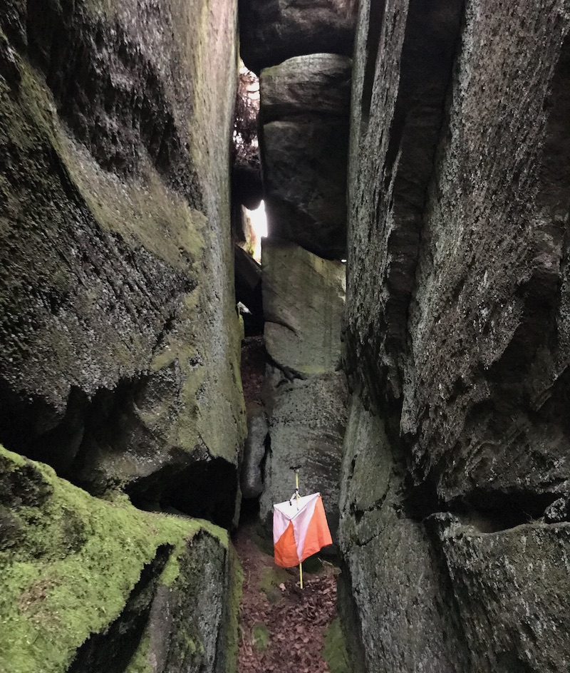
Control 17 lay inside a crack in the rock with people queuing (maybe there is something in that stereotype after all) for a chance to dib it. The crack was surprisingly narrow and I made the mistake of continuing through because I hate going back on myself, especially when other orienteers are breathing down my neck, and ended up out the other side of the rock which was in the opposite direction to my next control. Lesson learnt, plan ahead and ignore the orienteers behind you. I picked my way back round the crags and got back into the flow of things. The next few controls went pretty smoothly until I was faced with the general public and was again distracted by them. Control 20 was not a particularly difficult control but the combination of the public and the fact that I stupidly went in without a plan meant by the time I had got to the control circle I was a bit confused. I had expected to just see the kite but after some head scratching I realised I was on the wrong side of the boulder and this mistake had just been witnessed by a family of 5, not my proudest moment.
Onwards and upwards, for the next few controls I took more care to make sure I was on the right side of the rock formations, and it was all going quite well but alas disaster struck. Leg 25-26 was maybe one of the easier legs of the whole course and that meant I got complacent. Again, I went into it with no real plan (are we seeing a pattern here?) and again I paid the price. I ended up just running to two knolls that kind of looked like the control feature and shocker they were not. I didn’t realise my mistake until I had got there looked down and realised I was way above where I wanted to be. Not a lot of time wasted on this leg but enough to feel a little bit stupid. I slogged my way back up hill to number 27 and vowed to make it to the end without further mistakes (spoilers – I didn’t).
Leg 29-30 was a bit tedious and to be honest I didn’t really want to go all the way back towards the start area only to come all the way back to the finish again but actually it was quite nice to run freely without fear of falling between two boulders! After the long leg and on my way to control 31 I could practically smell the finish, and this would prove to be my downfall. The momentary lapse in concentration meant I had lost track of the paths and found myself on the wrong one and at the wrong rock formation. Now because I apparently trust myself a lot, I briefly thought someone had nicked the control because there was no way I could be in the wrong place, right? Wrong, I was. I looked more closely at my map. It didn’t help that the number 31 was covering the feature, and I realised I had indeed gone too far to the right and to my left was the actual control feature.
I rectified my mistake and got back on my way to glory. I’ll be honest I can’t really remember the last few controls which I think means they went well (?). I had made a few mistakes, but they were minor, whilst mostly taking the whole course quite slow to avoid any full headless chicken errors (and that worked). Overall, I was happy with my performance and had thoroughly enjoyed the complex navigation the area provided.
60 Seconds with…..Dave Peel
Dave Peel answering questions from the Warrens

What’s your role in the club? No real role on the committee, though seem to end up organising meals etc.
How long have you been orienteering? Started about 4 years ago, with my first event at Auckland Park.
How did you get into the sport? After completing the ‘Couch 2 5k’ program, Matthew suggested that I tried it as something to do when there was no water for kayaking.
What’s your warm-up routine? Running to the start, due to poor timing.
What’s your best result? Probably the October Odyssey event at Druridge Bay with 7th place on the lovely sand dunes.
What do you eat before your run? Cake, flapjack, and/or a banana, though it really depends what time the start is.
Thumb compass or base-plate? Thumb.
Do you take compass bearings? Frequently.
What’s your favourite orienteering area? Findhorn, with the mixture of sand dunes, some open and some forested. It’s one reason why I’m looking forward to the Scottish 6 Days this year.
Lycra or baggy? Lycra usually.
Moorland or forest? Sand Dunes! Possibly forested ones like the Findhorn map for the 2020 Scottish Night Champs!
Urban or cross country? Cross country though I do like a good urban map like Durham City, York, and the Edinburgh Big Weekend areas.
Do you pace count? Sometimes, depends on the terrain.
What’s your worst mistake? Attending the controllers course.
Are you a results nerd? I like to have a look at other people’s route choices, and do quite like the ranking points system.
What do you think of Routegadget? It’s a good resource to look at other people’s route choices, and to look at maps for future events.
CompassSport Trophy Heat: Part 3, Ollie’s favourite things
- The Cakes
- Getting there
- Being able to go to the Forest of Dean
- Being 1st on the White course by 13 minutes
- Being 2nd on the Yellow Course
- Dibbers
- Finishing
Edinburgh Big Weekend – Jan 2023
Matthew Foskett
Edinburgh Big Weekend was the first weekend of orienteering I did, back in 2016 with Durham University Orienteering Club. Since then I’ve been back each time – I love the variety: a sprint event on the Friday night, a long urban event on the Saturday and the classic on Arthur’s Seat on the Sunday.
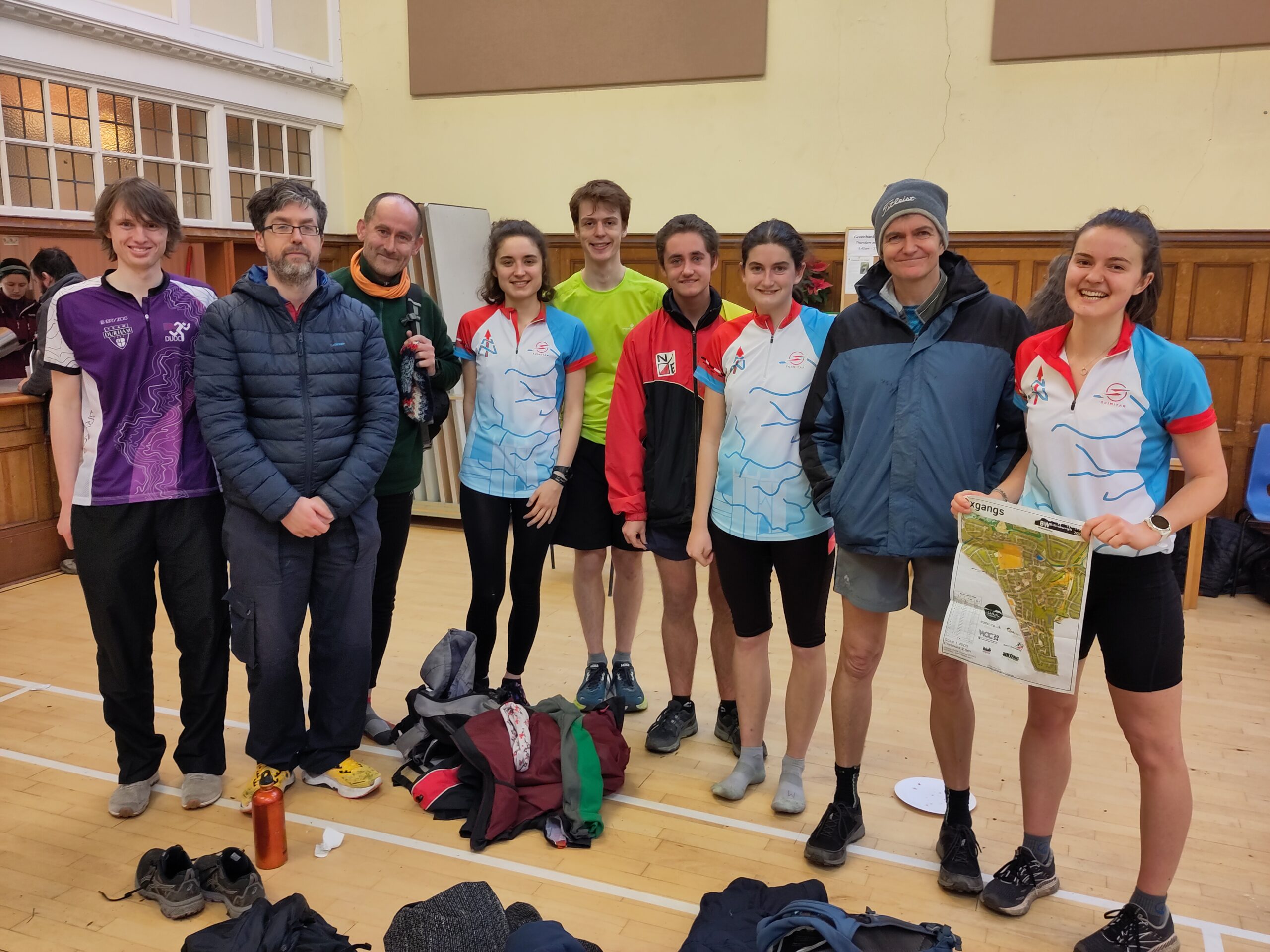
This year I headed up for all 3 days – arriving by train on the Friday night and staying in the Holyrood area with Dave, Elizabeth and Paul. There were 13 NN members – Debby, Julian, Barney, Naomi, Kate, Nigel, Jed, Maya and Yokub, in addition to those above, there for some or all of the weekend .
The first event was the Friday sprint, “Fight with the Night”. This was at Stewart Melville College and Dean Village. The Dean Village section had featured as part of a Saturday Urban event a few years back: it is a complex warren of streets and alleys on either side of the Water of Leith. The Stewart Melville College section was new to me: it was a school campus with some quite ornate buildings; it included some walls/fences and dead ends to keep you paying attention to the end.
Despite arriving with plenty of time, a slight miscommunication meant that both Dave and I were slightly late to our starts (we both knew roughly and that we were the same start time as each other, turns out neither of us knew the actual time!). No matter, there was lots of free slots and I was soon away.
The course started with a few controls along the banks of the Water of Leith including some nice Georgian Gardens where you had to stick to the paths or risk disqualification. After this followed the Dean Village section. This was made more complicated by a last minute change to the printing meaning you had to swap to a loose map extract at one of the controls. The numbering of the controls on the sheet had restarted at 1 in the description box whilst the numbers on the map had continued in sequence from the main map – this definitely messed with my head! There were also some additional roadblocks which you were forbidden to pass through… After leaving Dean Village I had to head up to the final section in the College. Here there was a sequence of controls in quick succession before I navigated to where I believed 25 to be and then paused, slightly confused – I was certain I was in the right place but no kite? At that moment I heard a shout above. There were some Scouts trying out the novice course in small groups and their discussion between themselves had alerted me to the fact that the control was above my head on a raised walkway! It wasn’t far to go, but a better reading of the map and descriptions would have saved me time. After that it was a few simple controls to the finish where there were a few more NN people waiting.
As three orienteering events isn’t enough running for one weekend, we headed to Holyrood parkrun on the Saturday morning. The parkrun had a great view over the city and it was interesting to spot the area for the Urban later in the day.
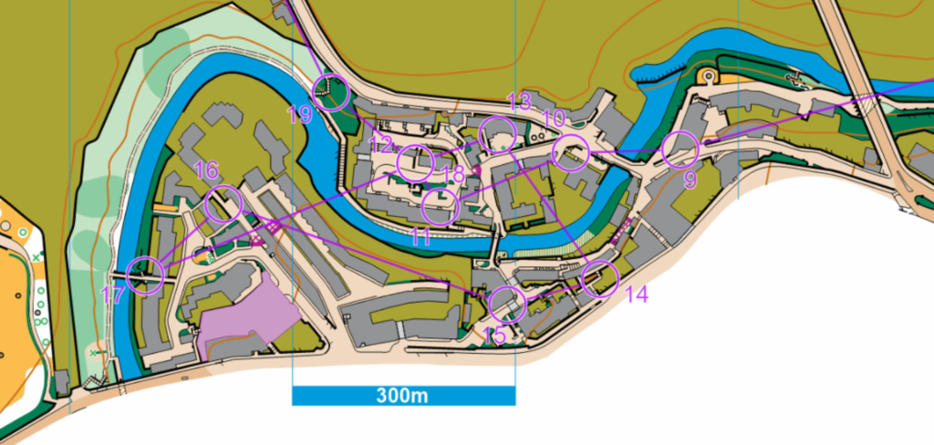
The Saturday Urban was in the south of the city – Edinburgh is hosting the World Orienteering Championships in 2024 and so much of the city is ’embargoed’, including the Royal Mile which is normally a favourite for the Saturday event. The embargo means that they cannot run orienteering events in those areas until after WOC 2024 – potential competitors and their support teams cannot even enter some of the areas! This meant it was a new area for me: Braidburn valley, Oxgangs and The Steils.
We got the bus there, before meeting up with some other NN. This included Naomi who was entering her first official orienteering event. We tried to give helpful guidance – hopefully we didn’t make it sound too confusing! Orienteering is definitely a sport that has quite a lot of jargon and (mostly!) makes a lot more sense by just giving it a try.
My course was 11.1km on paper and the watch read 11.27km when I finished so I was pretty happy – I’m hoping I can get back to running a bit faster over the year, but I was pretty happy with most of the navigation.
After heading back for dinner we then headed to an Edinburgh Big Weekend staple – the Saturday Night Ceilidh – before some well earned rest.
The Sunday event was the Classic on Holyrood Park Arthur’s Seat. I was on the Brown course. The event information suggested it would be a tough one and so it proved! There’s always a lot of up and down (as you’d expect if you’ve been to the area!), but this year was even more than usual. I ended up running about 13.5km and 686m elevation in a time of 111minutes 19 seconds. Elizabeth was ahead of me on 111minutes 6 seconds and Barney an impressive 93minutes 7seconds.
The course was a physical challenge, but also gave some thing to think about in terms of route choice with several long legs where you had a choice of up and over or contouring around. By the end I was exhausted which also made the decision making trickier, especially in some of the more complex areas of rocks and maze-like gorse.

I’d started pretty early which gave me time for an unplanned walk back to the accommodation (it turned out I’d still got one of the keys…) before heading with a group of NN to a café for a well earned break – everyone seemed to have really enjoyed the challenge. I had really enjoyed the weekend once again and it had made me keen to get a bit faster again for some of the orienteering to come later in the year.
Next year the Edinburgh Big Weekend format will be slightly different – as noted above Edinburgh is hosting WOC 2024 next year and so it’s billed to be sprint orienteering focussed on the 26-28th January 2024 to build up to the World Orienteering Championships in July (which will also be sprint format). It’s brilliant that the World Orienteering Championships will be nearby and there will be non-elite races as part of that too. Personally though, I’m looking forward to the year after when we hopefully return to the Royal Mile for the Saturday Urban!
Airienteers – Hebers Ghyll & Ilkley Moor West, 7th and 8th January 2023.
Max Wilkinson
This is a long one with much peripheral musing, unless it gets heavily edited prior to publication – you might want a cup of tea and a few biscuits (it’s ok to pause here, it won’t run off while you are putting the kettle on).
I seem to have an affinity to navigation on moorland as opposed to forest. Perhaps it’s the lack of branches to poke my eyes out, brambles to trip me up, or simply that I’ve spent more time running on moorland, having been a fell runner for many years before finally taking up orienteering in earnest this October. Not that I shy away from the challenge of forest navigation, but when I saw the Saturday night and Sunday morning double event at Ilkley Moor run by Airedale and Wharfedale based Airienteers it went straight into the calendar. Described as follows:
‘Hebers Ghyll Woods is a single slope of mixed forest. It is well used by the public so there are many small paths – not all are on the map. The orienteering is interesting although there is more bramble than there used to be with some dead bracken. Ilkley Moor West is typical moorland with crags and steep slopes and good route choices. At present there is a lot of dead bracken (which is marked on the map). We hope this will have flattened by early January. Both areas contain some big crags – take care.’
This would be my first time at an event organised by AIRE and I like to see how different clubs run their events, there is always something distinctive that gives you a small insight in to the club.
Location wise it also worked well being part way home to Durham from my parents’ house in West Yorkshire – a good way to split up the journey before I finally return home for that dreaded first day back at work following the festive break.
While doing some pre-event research it become apparent that Ilkley Moor is the location of a famous alien abduction, commonly termed ‘The Ilkley Moor UFO Incident’. You can read more about the incident here and here.
Needless to say, that I’d be running alone at night on the moor where a (mostly) undisputed alien abduction took place certainly added another dynamic to the event. There’s even a UFO landing pad mown in to the heather (ISOM take note, candidate here for inclusion in next symbol specification) I wonder if that’ll be one of the controls?
I thought all this was very cool, however on with the article.
My plan was to run the Saturday night event, not make a complete mess of it. Park my van as close to the Sunday morning start as possible and go for a sub-20-minute PB of waking up to start-funnel, that way the weekend would be a success regardless of my o-game.
As it turned out after a bit of faff I got a decent parking spot on Saturday night at ///comedians.digits.sideburns (see fig. 1, below), appraised in detail using the following criteria:
View: It was dark 1/5
Peacefulness: Semi-rural access road to the moor and Ilkley suburbs, some late-night traffic doing burnouts and emitting stale cannabis smoke 2/5
Local craic: Only the occasionally high-speed pass from the local boy racers 4/5
Drainage & hardstanding: Even but slightly sloping tarmac with gutter drainage, no puddles 4/5
4G signal: Full signal inside the van 5/5

A very good score by vanlife standards, but alas its major let down was proximity to the start, it took me 35 minutes from waking to start-line, partly due to a long walk in from assembly – well outside PB territory, best hope for a decent run then. But before we cover the Sunday morning performance, I should first present the antics of the preceding evening, this being a well-structured article and not some incoherent ramble.
Hebers Ghyll & Ilkley Moor West – Night Event
The following will make more sense with the event map, course and my trace open as you read, which can be found here.
There were short, medium and long courses on offer. I’d entered the long course as I fancied a decent run out and as a beginner orienteer with decent fitness I figured more control-finding would be of benefit. Advertised as 4.9 km, 250 m ascent, 16 controls. What could go wrong?
I arrived at the advertised assembly location and was ushered to a parking spot by the yellow-jacket crew. A quick change of clothes, bite of chocolate and a few stretches had me ready to go. My start time was 17:31, so I was at the start funnel in the woods at the bottom of the hill a few minutes early.
The start marshals (not sure of the o-specific job title yet, controller? planner?) were keen to wait until 17:30 but after that we could ignore our booked start time and go whenever we liked. There were two other people waiting to run the medium course, so I was allocated a start time with one of them as I was on the long course. This, I think, meant that I was first out on this course and more importantly that there’d be a hoard of eager orienteers running me down from the get-go. I tried to ignore this fact as I dibbed the start control, set my watch off and picked up my map. I located the start control on the map, orientated it north and checked the map scale as I jogged off towards the first control. I carefully counted my paces. The first control being located in a stream gully. After a few minutes of climbing fallen trees and jogging through undergrowth I heard the sound of rushing water. I approached, partly confident, and partly not, as I had not aimed off, so if the control wasn’t right in front of me it’d be pot luck on which way to head along the gully to find it. As luck would have it as I crested the edge of the gully the control was right in front of me. Winner! This is actually going to go well! And it did, for the most part, for controls 2-9. I kept a steady average pace and could feel myself getting more attuned to the map and the environment. Control 4 onwards was out on to the open moor, a long traverse east across the predominant terrain slope, which put me further at ease. Good running, some paths and good visibility of the shape of the ground played to my favour. I was trotting along nicely, focussed on my map, the features lit by my headtorch and not at all thinking about aliens. The weather was dry, cold and a little windy with good visibility. The ground was saturated, which will come as no surprise!
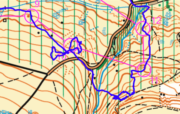
It was all going to plan, I navigated nicely to control 9 (see fig. 2 below), doubled checked the code here against the control description (thanks for the tip Liz), headed south-east towards control 10 (a depression), slightly off course I found the boulder part-way along the leg and recorrected my course, which made me parallel to where I really needed to be. The upshot, unbeknown to me, was that I missed the control slightly to the south, then I got that ‘I should be there now’ feeling and spotted the tarmac road in front of me. This completely threw me, I hadn’t looked past the control for the road as a backstop and really wasn’t expecting to find it at this point. I got beginner’s dread, have I run off the map? Did I align to south instead of north? I rationalised my situation, the road was on the map, almost where I was expecting to be, I can sort this out with minimal drama. So, what to do next? My immediate thought was that the control must be uphill, as drifting downhill while contouring is easy to do, so I headed that way, had a wander about amongst the parallel network of erosion gullies with no luck, then decided to take a look at the shape of the road. I figured I was too far south, so set off north and downhill on another bit of a wander and eventually found the control. A good few minutes lost here and all that faff had mentally tired me out – can we stop the course here please?!
I set off from control 10 towards 11 and this is when the real fun began. I took a glance at the control descriptions, control 11: knoll. Ok, I like those, that should be easy to find. I followed the road, then crossed a deep river gully, then started to climb up hill, all going to plan I thought. A few knoll-looking features were up on the moonlit skyline ahead, so up I clambered, then I hit a track. Oh no, that shouldn’t be there! I figured I’d run past the control and the road was again the backstop. I was on a narrow ridge running parallel to the track, which matched to some degree what was on the map, so the control must be on one of these knolls on the ridge. I jogged further along the ridge to get more info on its shape. At this point my cumulative-faff had meant that a stream of headtorches were now heading my way and getting closer all the time. I continued with my plan, keep searching the ridge. I checked two other locations and no joy. So, what to do now? I kept looking at the map while the stream of headtorches closed in on me. Well at least these people will know where the control is, I’d done well to get this far so I can ‘cheat’ (at least in my book) and follow them to this one. I was waiting on the top of the ridge for them to make their way up, except they were staying on the low ground and searching the small valleys. That’s not right.. I checked the control descriptions again, control 11: re-entrant; control 12: knoll. After all the drama at control 10 I’d misread the description of 11. I was looking for entirely the wrong feature! I crashed back down the steep bracken slope to the group of headtorches below. I found control 11 with a bit of help from my new found friends, then followed the pack onwards to 12, which of course was on a small knoll.
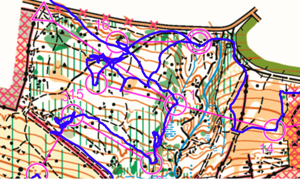
At this point we descended north off of the moor and back into the woods. I followed the group for the most part, being led to 13 (isn’t it easy when someone else is doing most of the nav and you just check the map now and again, I could get used to this!) and was proud to lead the group to control 14, I had chance to look ahead and had my route to control 15 and my bearing mostly figured out. I decided to sprint on ahead. A big mistake in hindsight, but I’m here to learn by my mistakes, figure things out for myself and not to follow the leader. Having headed west from control 14 (see fig. 3) I decided the straight line route to 15 would be inaccessible, there being a significant gorge on-route and so descended north parallel to the gorge, through the finish (yes, logical, I know..) and climbed the hill from the south on the same side of the gorge as control 15. I accomplished this in a reasonable time relying on my fell running fitness. The group I’d just departed had traversed directly across the gorge and were just ahead of me. My impromptu detour had got me to where I needed to be, but with no definite plan to navigate the final section to the control. I needed to stop and figure this out. More time lost. There was a network of paths in the woods, many of which were not mapped, so it took me some time to locate myself exactly and navigate to the control. I navigated to control 16 easily on the descent, which partly restored faith in my ability to navigate and I enjoyed the final dash to the finish.
Post event analysis: Phew, quite an ordeal. I seem to be doing well when I’m doing well. But once things start to go wrong, I find myself making errors on the next leg. Note to self to really take it steady for a control or two after which I make a mistake and try to do the basics well. I ran 6.8 km and 362 m ascent of an advertised 4.9 km and 250 m ascent. All-in-all a great event. I enjoyed being out on the moor, more so than in the woods and this was definitely a learning experience.
I finished 22nd from 34 starters. You can view the full results here.
Hebers Ghyll & Ilkley Moor West – Day Event
5.5km, 230m ascent, 16 controls.
Okay, on to the day event. A warm meal and a good sleep in the van had me ready for the next morning. A similar course in the same area, but with the added benefit of daylight. As before, you can view the map, course and my trace here.
There were coloured courses on offer this time. A comprehensive array of white, yellow, orange, short green, green, blue and brown. I’d gone in for the brown for similar reasons to choosing the long night course, a decent run out and plenty of controls to find. The course was advertised as 5.5km, 230m ascent and 17 controls.
The weather had settled further from the previous night, with the wind dropping. It was overcast and generally good conditions for running. The course began at the top of the wooded area leading out on to the moor for the first 11 controls on an eastward and then westward traverse, with the final 6 controls in the woods to finish. Leg 5 stood out in particular, being 1,300 m in length.
So, on to the start. I felt comfortable of an improved performance this morning. Or at least I wouldn’t be making the same mistakes as last night. I’m at the stage where I’m making new mistakes each time I run, hoping that I will eventually get through all the significant mistakes soon. Let’s see what this throws up.
You can see my path for leg 1 in fig. 4 below. It did not go as expected! I did everything I’d done at previous starts, dib the start (haven’t made that mistake yet!), pick up the correct map, locate the start triangle, orientate to north and head off on the bearing to the first control. As I set off from the start I immediately hit a set of paths that were branching off from my bearing at a very low angle. I seemed to have ‘picked’ the wrong path and while continually checking my bearing was about right, as the path wiggled around, I was able to drift away from my intended destination. I don’t think you can call this a parallel error, as looking again at the map I was to the south of a significant northward slope. I should have spotted that the steep slope should have been on my left and not my right. In fact, I had a reasonable mental picture of the area having run through here the night before. I think what threw my translation of map to my view of the terrain and vice-versa was the fact that the slope on the right was so steep it was effectively out of view and so I didn’t include it in my mental picture. I had a gentler slope to my left and interpreted this as the steep slope I should have been seeing on the map. So, as you can see from my trace (fig. 4) I headed west for some distance, found a control, realised I was in the wrong place, swore under my breath and eventually figured out what I’d gone wrong, but it did take some time. A good couple of minutes lost here. Once I’d figured it out I headed north and quickly located the first control, but this was really not the start I’d hoped for. Oh well, at least that’s my error out of the way now and I can crack on. (Thanks to Meg for mentioning at the Christmas meal that she took 20 minutes to find the first control at an event once, made me feel a bit better 😊).

In fact, things did go quite well from there on, at least for a time. I located control 2 easily, a little misread for control 3 lost a bit more time (still flustered from my error on the first leg). Leg 4 and the long leg 5 all went well. I’d warmed up by then and enjoyed the sprint across the moorland tracks. There was a bit of route choice on leg 5, including utilising minor tracks to contour around a hill. Control 5 was located on a manmade cane tripod – I didn’t stop for long to inspect it, but it looked like it was constructed just for this event, which was interesting to observe. Onwards to legs 6 and 7 in a small wooded area on the moor. I’d caught a few runners up by now and things were going better. Leg 8 started in a similar fashion, took the bearing and set off through piles of dead bracken and undulating terrain. I located the boulder to the west of the leg bearing – but this being a mapped feature I felt the need to run right past it and in doing so pulled me off course. When I reset my bearing I was travelling parallel to where I needed to be heading, the result being I entered the more complex terrain close to the control to the west of where I expected to be. The terrain here was a small network of re-entrant covered in deep layers of dead bracken. This made locating the control a challenge. I knew I was close but it took a bit of a circular loop to finally locate and I’d only missed it by perhaps 10 metres on my first pass. Leg 9 was slightly longer with some route choice. I made a mistake here and headed up the hill too far when I could have headed directly west to the road. You will notice this is the ‘ridge’ area where I made my big mistake locating control 11 on the night course. I must really like this particular hill for some reason, however I plan for this to be my final visit. I realised the error in my route choice and managed to join back up with the direct path heading west, not too much time lost here and a nice bit of hill training done along the way.
The remainder of the course went mostly to plan. I had a few minor errors locating controls, particularly in the woods towards the end of the course, but nothing major.
Post event analysis: Ah, that big error on leg 1. I was gutted when I realised what I’d done. I felt like walking back to the start and asking to start again. In any case I did get things back on track, with my knocked confidence affecting leg 3 a little, but I felt I was able to put this one behind me. The other errors on the course were relatively minor. So overall I’m happy with my performance here. I can’t call it a success. Looking back at both events I feel like I am gaining in experience now and consistency is coming, of sorts, but I’m still prone to making quite big (timely) errors. I guess this is to be expected when running long courses with many legs such as these. I could run shorter courses and perhaps gain some more consistency, but I feel happy running the longer courses for now and applying the basics correctly 70-90% of the time. A pretty significant milestone for me would be to navigate almost directly to all controls on a course such as this, but not at speed. My approach for future events will be to spend more time looking at the map and adjusting my speed accordingly to make time for map reading. I ran 7.6 km and 333 m of ascent of an advertised 5.5 km and 230 m of ascent.
I finished 26th of 33 starters. I lost around 4 minutes on leg 1, without which would have put me around 18th. You can view the full results here.
Introductory guide – control descriptions
Matthew Foskett
What are they? They are little symbols which tell you at what ‘feature’ you’ll find the control kite.
Where will I find them? They’ll normally be in a table on your map with a row for each control. You often also get given a loose copy which you can attach to your arm (or elsewhere if you prefer!) if you have a control description holder.
What counts as a feature? Features fit into several categories: contour features (e.g. a spur or a pit), a natural rock feature (e.g. a cliff or a boulder), a water feature (e.g. a lake or a stream), a vegetation feature (e.g. a tree or a thicket) or a man made feature (e.g. a fence or a building). There are also two symbols for special features – these will be defined on the event details.
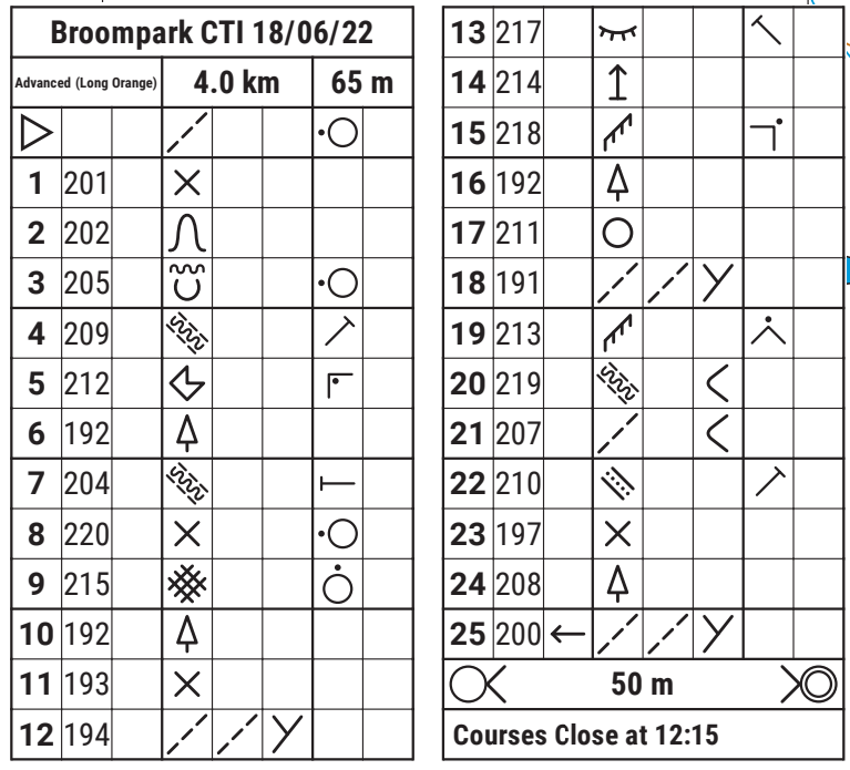
Why so many columns? As each column contains a different piece of information. From left to right:
- The 1st column is the control number – this is the order in which you visit the controls (except on a score course where you can visit in any order)
- The 2nd column is the control code – this will be the number you can find on the control. This allows you to check you are at the correct control.
- The 3rd column tells you ‘which one’. If there are multiple of the feature you are going to within the control circle, it tells you which one you should go to (e.g. the western path junction for control 25 in the image above)
- The 4th column tells you the feature.
- The 5th column tells you either the second feature (if the control is where two features meet) or gives a description (e.g. broad leaved if it is a tree).
- The 6th column tells you the type of junction if it is where two features meet (e.g. junction or cross roads) or gives a size/height of the feature. It is also the box where a bend would be indicated (e.g. if the control is at a bend in a path).
- The 7th column tells you where the control is located on a feature (e.g. north side for control 9 in the example above) – this is important for larger features or features such as walls where you could end up with a long way still to go if you chose the wrong side!
Do you actually find them helpful? I have to admit, 7.5 years after my first orienteering event I still occasionally find myself looking at some of the more obscure symbols in confusion… However, I’d definitely recommend getting to know the common features. Why? As otherwise it can become a bit of a treasure hunt – even if your navigation to the edge of the control circle has been spot on, each control circle is normally 75m in diameter which is quite big when you’re looking in the wrong pit or the wrong side of a thicket! Also, on some urban races the control could be on a feature on a bridge above your head or the other side of an uncrossable wall.
How can I learn them? A simple guide showing all the symbols can be found on the Maprunner website here – there’s also a quiz on there to help you check your knowledge… If you want the full guide you can check it out on the IOF website here.
Please send any contributions for the June newsletter to [email protected] by Wednesday 21st June.